¶ Data Coverage and Sources
This section describes the data sources, spatial and temporal coverage, and selection logic used by LuData to deliver irradiance, meteorological, climate, and terrain-related services.
LuData is designed to abstract data source complexity from users. Users request services and variables, while the platform automatically selects, processes, and delivers the most appropriate data.
¶ Satellite coverage
LuData relies on multiple regional and global satellite missions to provide irradiance data.
Coverage varies by region and time period.
The interactive map below illustrates the spatial footprints and temporal availability
of the main satellite sources currently used by the platform.
Interactive coverage map. Open in a new tab
¶ Multi-satellite strategy
There is no single satellite mission that provides optimal coverage and resolution worldwide.
LuData therefore adopts a multi-satellite strategy.
Depending on the geographic location and time period, different satellite missions may offer:
- better spatial resolution
- longer historical depth
- improved temporal continuity
- better viewing geometry
LuData continuously maintains compatibility with multiple satellite sources in order to:
- maximize spatial resolution when available
- ensure long-term temporal coverage
- avoid gaps at regional boundaries
Users are not required to select satellites manually.
¶ Automatic source selection
When a user creates a scenario (via the UI or API), LuData automatically performs the following steps:
- Identify the site location
- Evaluate the requested time period
- Check satellite and reanalysis availability
- Select the best available source based on:
- spatial resolution
- temporal availability
- continuity over the requested period
- Process and deliver the requested outputs from our internal servers.
This guarantees that users never receive lower-quality data when a better source is available for the same request.
¶ Spatial resolution (typical values)
The table below summarizes typical native spatial resolutions of the main data sources that we self-host and process to efficiently distribute it and transform depending on the request.
Actual original resolution may vary slightly depending on location and period.
| Data source type | Typical spatial resolution |
|---|---|
| Meteosat (Prime / IODC) | ~3–5 km |
| GOES-East | ~2–4 km |
| Other regional GEO satellites | ~2–5 km |
| ERA5 reanalysis | ~30 km |
| Terrain / DEM (Copernicus GLO-30 class) | ~30 m |
Satellite-derived irradiance is always preferred when available,
while reanalysis data provides global consistency for meteorological variables.
¶ Temporal resolution
LuData supports the following output time resolutions, depending on the service and data availability:
- 10-minute
- 15-minute
- 30-minute
- Hourly
This applies to:
- Historical Time Series
- Typical Meteorological Year (TMY) outputs
The selected temporal resolution is applied consistently across all requested variables.
¶ ERA5 & reanalysis data
LuData integrates ERA5 reanalysis as a global reference dataset for meteorological and climate-related variables.
ERA5 is used for:
- temperature
- wind speed and direction
- humidity
- pressure
- precipitation
- other climate-relevant variables
ERA5 provides:
- worldwide coverage
- physically consistent time series
- long historical depth (since 2000)
ERA5 complements satellite-derived irradiance data
and serves as a stable backbone for energy, agriculture, and climate modelling workflows.
¶ Update frequency & data latency
LuData operates on a monthly update cycle.
At the end of each month:
- the full previous month of data is fetched
- data is processed, validated, and prepared
- datasets are stored internally and made available for user requests
As a result:
- users always access complete and consolidated months
- processing and accounting remain consistent across services
The most recent available data typically corresponds to the end of the previous month (we will provide soon in feature releases near real time up to last 5 days).
¶ Terrain & elevation data
Terrain-related services rely on a self-hosted digital elevation model (DEM).
From this DEM, LuData derives:
- Grid Elevation: elevation values over a defined area around a site
- Horizon Profile: horizon relief as a function of azimuth and distance
These products are critical inputs for:
- solar resource assessment
- horizon shading analysis
- yield and performance modelling
- site engineering studies
Terrain services are independent of satellite irradiance availability.
¶ TMY historical depth requirements
Generation of a Typical Meteorological Year (TMY) requires sufficient historical depth to produce statistically meaningful results.
LuData applies the following rule:
- a minimum of 10 years of historical data is required to generate a TMY
If the requested period does not meet this requirement,
TMY options may be restricted or unavailable for the selected site.
¶ Access modes and transparency
- When using the web interface, all source selection and processing logic is handled automatically.
- When using the API, users benefit from the same source selection logic, while retaining full control over integration and downstream processing.
If a specific dataset, constraint, or custom configuration is required, users are encouraged to contact Lucisun for guidance.
We can process to increase our documentation that we make available to our customers through this Docs (wiki) or via the API DOCS.
¶ Summary
LuData provides unified access to:
- multi-satellite irradiance data with optimized spatial resolution
- global reanalysis data (ERA5)
- high-resolution terrain and horizon products
Coverage and availability are transparent through the interactive map,and data is updated on a monthly basis to ensure consistency and reliability.
¶ Services
LuData provides a set of data services delivering irradiance (using satellites), meteorological & climate (via Reanalysis from ERA5), and terrain-related (GLOB-30 DEM) data through a unified platform.
All services:
- Are accessible via Web UI and REST API (unless stated otherwise)
- Follow a request-based consumption model
- Use automatic data source selection
- Produce standardized, traceable outputs for downstream analysis
This section describes each service, its scope, configuration options, and outputs.
¶ Historical Time Series Data (HTSD)
The Historical Time Series Data (HTSD) service provides long-term historical time series for irradiance and meteorological variables at a specific geographic location.
¶ Typical use cases
- Solar resource assessment
- PV and energy yield modelling
- Performance benchmarking
- Long-term climate and meteorological analysis
¶ Data availability
| Aspect | Description |
|---|---|
| Historical depth | Typically from 2009, depending on site location |
| Data latency | Available up to one month before the current date |
| Update cycle | Monthly, with full consolidation of the previous month |
¶ Temporal resolution
HTSD outputs can be generated at the following time resolutions:
- 10-minute
- 15-minute
- 30-minute
- Hourly
¶ Time reference & timestamp convention
| Parameter | Options |
|---|---|
| Output timezone | UTC, Local time |
| Timestamp convention | Left (forward) (default), Instant, Right (backward) |
¶ Mounting configuration
Users can specify the system mounting configuration:
- Fixed mount
- Single-axis tracking
- Dual-axis tracking
This configuration is required for tilted irradiance variables.
¶ Available variables
Our users are invited to contact us or give us feedback in case they would like to have specific variables that we currently dont support.
We do have the flow in place to have additional variables that can be added in less than a month.
We are having a focus on Solar data needed by the industry but more variables needed by people in the Climate and Agricultural sciences will be added.
¶ Irradiance variables
| Variable | Description | Unit |
|---|---|---|
| GHI | Global Horizontal Irradiance | W/m² |
| BNI | Direct Normal Irradiance | W/m² |
| DHI | Diffuse Horizontal Irradiance | W/m² |
| GHI_csk | Clearsky Global Horizontal Irradiance | W/m² |
| GTI | Global Tilted Irradiance | W/m² |
¶ Meteorological variables
| Variable | Description | Unit |
|---|---|---|
| Tamb | Ambient temperature at 2 m | °C |
| RH | Relative humidity | % |
| SP | Surface pressure | hPa |
| TP | Total precipitation | m |
| WS10m | Wind speed at 10 m | m/s |
| WD10m | Wind direction at 10 m | ° |
¶ Output formats
| Format | Description |
|---|---|
csv-lusim |
Default internal format |
json-lusim |
Structured JSON output |
csv-pvsyst |
PVsyst-compatible format |
Additional formats can be provided upon request.
¶ Availability
| Access mode | Available |
|---|---|
| REST API | Yes |
| Web UI | Yes |
¶ Consumption model
| Rule | Description |
|---|---|
| Billing unit | Per request |
| Credit definition | 1 request = 1 variable × 1 year |
| Consumption | Only when data is actually delivered |
| Validity | Credits remain valid until the end of the year |
This model supports both small-scale studies and large portfolios.
¶ Typical Meteorological Year (TMY)
The Typical Meteorological Year (TMY) service generates statistically representative years based on long-term historical datasets.
¶ Typical use cases
- Energy yield simulations
- Feasibility studies
- Standardized performance comparisons
- Long-term planning and modelling
- etc
¶ Data requirements
| Requirement | Description |
|---|---|
| Minimum historical depth | 10 years |
| Data usage | Full available historical period is used |
If the requirement is not met, TMY generation may be restricted or unavailable.
¶ Technology type
The selected technology influences variable weighting during TMY generation:
| Technology | Description |
|---|---|
| PV | Photovoltaics (default) |
| CSP | Concentrated Solar Power |
| CPV | Concentrated Photovoltaics |
| Tracker | Tracking systems (Single axis and dual axis) |
¶ Temporal resolution
| Resolution | Availability |
|---|---|
| Hourly | Yes |
| Sub-hourly | Available through API (soon will be up to date on LuData UI) |
¶ Time reference & timestamp convention
| Parameter | Options |
|---|---|
| Output timezone | UTC, Local time |
| Timestamp convention | Left (forward) (default), Instant, Right (backward) |
¶ Mounting configuration
- Fixed mount
- Single-axis tracking
- Dual-axis tracking
¶ Variables included
¶ Always included by default
- GHI — Global Horizontal Irradiance (W/m²)
- BNI — Direct Normal Irradiance (W/m²)
- DHI — Diffuse Horizontal Irradiance (W/m²)
- GHI_csk — Clearsky Global Horizontal Irradiance (W/m²)
¶ Optional variables
- GTI — Global Tilted Irradiance (W/m²)
- Tamb — Ambient temperature at 2 m (°C)
- RH — Relative humidity (%)
- SP — Surface pressure (hPa)
- TP — Total precipitation (m)
- WS10m — Wind speed at 10 m (m/s)
- WD10m — Wind direction at 10 m (°)
¶ csv-pvsyst limitation
When using csv-pvsyst, only the following variables are returned:
- GHI
- Tamb
- DHI
- BNI
- GTI
- WS10m
- WD10m
¶ Percentiles
Available TMY percentiles:
- P50
- P75
- P90
- P95
- PXX (custom)
¶ Performance
| Scenario | Typical execution time |
|---|---|
| Multi-variable TMY over long periods | < 42 seconds |
¶ Availability
| Access mode | Available |
|---|---|
| REST API | Yes |
| Web UI | Yes |
¶ Consumption model
TMY pricing is request-based and typically consumes more credits due to:
- long historical depth
- number of variables required
Credit usage is proportional to the data volume used to generate the TMY.
¶ Digital Elevation & Horizon
The Digital Elevation & Horizon services provide terrain-related data derived from a self-hosted digital elevation model (DEM).
These services are independent of satellite irradiance availability.
¶ Elevation – Point
Returns the elevation at a single geographic point.
| Attribute | Value |
|---|---|
| Data source | Copernicus Digital Elevation Model |
| Spatial resolution | ~30 m |
| Consumption | 1 request per call |
| REST API | Yes |
| Web UI | Not yet |
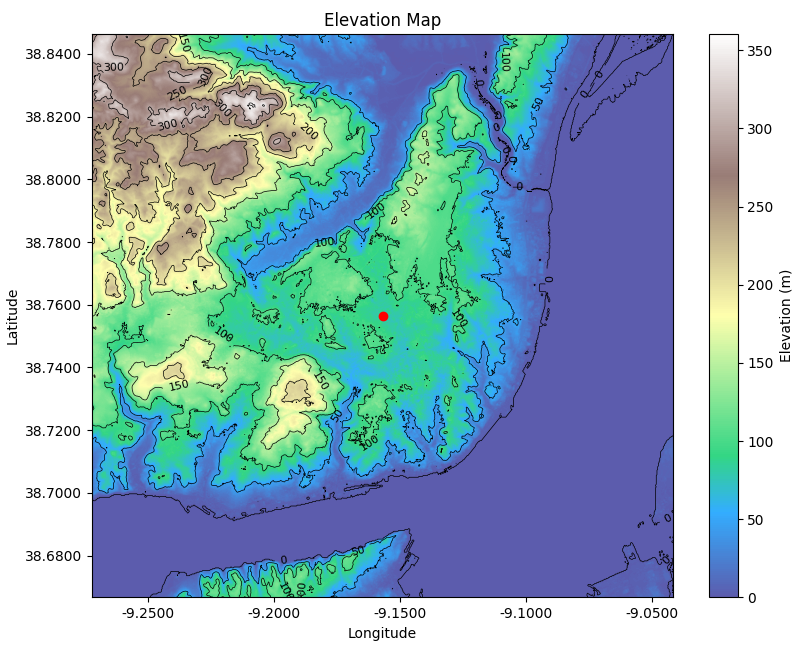
¶ Elevation – Area
Retrieves elevation data over a square area centered on a given location.
| Attribute | Value |
|---|---|
| Area definition | Square with side length = 2 × distance_km |
| Grid resolution | User-defined |
| Data source | Copernicus DEM (~30 m) |
| Consumption | 1–4 requests (depending on precision) |
| REST API | Yes |
| Web UI | Not yet |
Example output (elevation grid over a requested area): The following plot was generated using our internal functions and can be as well obtained as output for any site on earth
¶ Horizon profile from a location
Computes the horizon profile (maximum elevation angle) around a site.
| Parameter | Description |
|---|---|
| Azimuth range | 0°–360° |
| Azimuth step | User-defined |
| Observer height | Configurable |
| Output | CSV |
CSV output fields
- Azimuth direction (°)
- Latitude and longitude of highest point
- Elevation of highest point (m)
- Horizon angle (°)
- Distance to horizon point (m)
| Access mode | Available |
|---|---|
| REST API | Yes |
| Web UI | Not yet |
Example visualizations (derived from horizon profile data):
| Polar horizon view | Sun-path view (PVSYST-style) |
|---|---|
 |
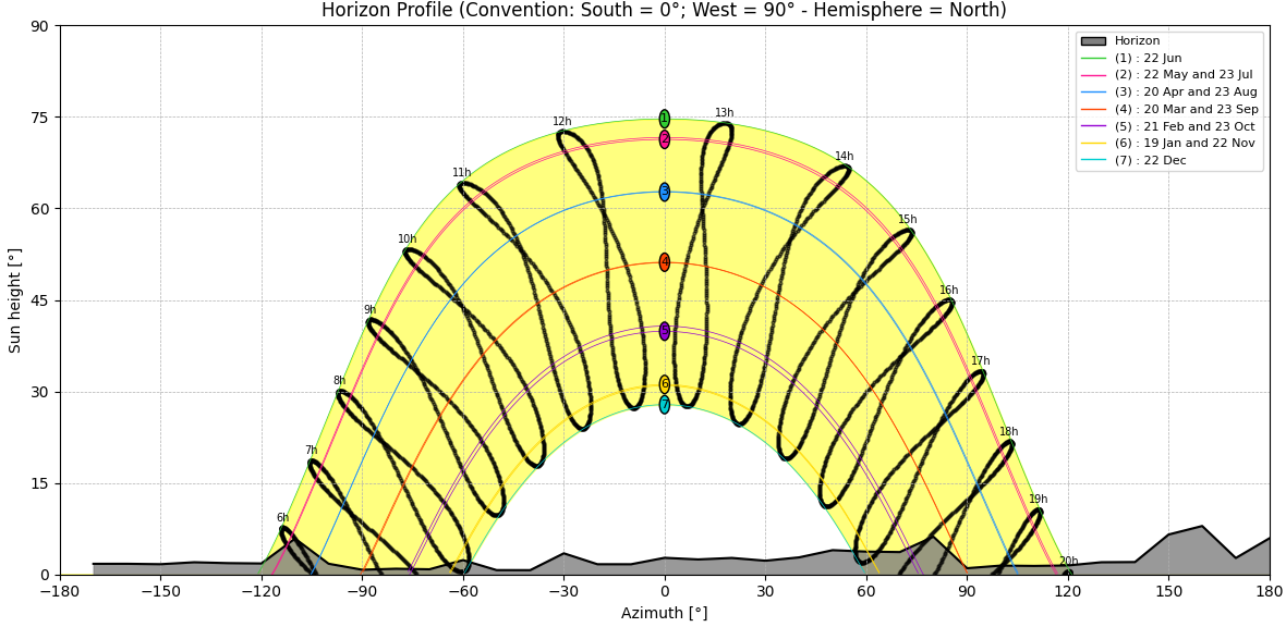 |
¶ Visualization support
Functions for generating elevation grids and horizon plots are available through
Lucisun’s open-source repositories but as well can be otained as output at every scenario request inside the gzip file and goes along with the output dataself itself.
¶ Results, Outputs & Conventions
This section describes how LuData delivers results across all services, including output structure, supported formats, metadata, and conventions.
These rules apply to:
- Historical Time Series Data (HTSD)
- Typical Meteorological Year (TMY)
- Digital Elevation & Horizon services
¶ Output packaging
All LuData services return results as a compressed archive.
- One archive is generated per scenario
- Archive format: ZIP or GZIP
- Archives contain one or more files depending on the service
This ensures portability, reproducibility, and long-term traceability.
¶ Scenario-based outputs
Each request executed through the Web UI or the REST API creates a scenario.
¶ Web UI
- Scenarios remain accessible after execution
- Outputs can be downloaded at any time
- No re-computation is required
¶ REST API
- The API response directly returns the compressed archive
- One API call corresponds to one scenario
¶ Supported output formats
LuData supports the following formats:
- csv-lusim
Default format following Lucisun internal conventions, recommended for analysis and scripting. - json-lusim
JSON format intended for programmatic workflows. - csv-pvsyst
CSV format compatible with PVsyst for direct import.
Format availability depends on the selected service.
¶ Common file structure
CSV outputs from HTSD and TMY follow the same structure:
- Metadata header (commented lines starting with
#) - Column header
- Time series data
¶ Metadata header
Each output file includes a metadata header.
Typical fields include:
- File generation date (UTC)
- Coordinates (latitude, longitude)
- Altitude (meters above sea level)
- Inclination (degrees)
- Azimuth (degrees)
- Data resolution
- Reference period
The reference period applies to:
- the requested historical time range (HTSD)
- the historical pool used to generate a TMY
¶ Data sources
LuData outputs are generated from Lucisun’s proprietary climate database, integrating:
- satellite observations
- atmospheric reanalysis (ERA5)
- internal processing and quality control pipelines
This information is documented in each output file.
¶ Variable naming and units
¶ Irradiance variables
- GHI: Global Horizontal Irradiance (W/m²)
- BNI: Direct Normal Irradiance (W/m²)
- DHI: Diffuse Horizontal Irradiance (W/m²)
- GHI_csk: Clearsky Global Horizontal Irradiance (W/m²)
- GTI: Global Tilted Irradiance (W/m²)
¶ Meteorological variables
- Tamb: Ambient temperature at 2 m (°C)
- RH: Relative humidity (%)
- SP: Surface pressure (hPa)
- TP: Total precipitation (m)
- WS10m: Wind speed at 10 m (m/s)
- WD10m: Wind direction at 10 m (°)
¶ Historical Time Series outputs (HTSD)
- One data file per scenario
- One timestamp column
- One column per requested variable
Supported temporal resolutions:
- 10-minute
- 15-minute
- 30-minute
- hourly
The selected resolution is documented in the metadata header.
¶ Typical Meteorological Year outputs (TMY)
- One file per percentile (P50, P75, P90, etc.)
- Hourly resolution only
- Full synthetic year (8760 timestamps)
TMY files include a list of representative months indicating which historical year was selected for each calendar month.
¶ Time conventions
¶ Timezone
- UTC (default)
- Local time (including daylight saving time)
¶ Timestamp alignment
- Start of interval or left or forward: timestamp marks the start of the interval (DEFAULT)
- Center of interval or instant: timestamp represents the measurement instant
- End of interval or right or backward: timestamp marks the end of the interval
¶ Spatial conventions
- Latitude and longitude are expressed in decimal degrees
- Altitude is expressed in meters above sea level
- Tilt convention: 0° corresponds to a horizontal plane
- Azimuth convention: 0° corresponds to North, positive clockwise (90° is east and South is 180°)
¶ Units
All values use standard physical units:
- Irradiance: W/m²
- Temperature: °C
- Wind speed: m/s
- Wind direction: °
- Pressure: hPa
- Precipitation: m
- Elevation: m
¶ Licensing and disclaimer
Each output file includes:
- licensing information
- a disclaimer regarding meteorological uncertainty
- recommendations to validate results using multiple data sources
¶ Summary
LuData outputs are:
- scenario-based
- metadata-rich
- consistent across services
- suitable for engineering, modelling, and analytical workflows
The same conventions apply whether data is accessed via the Web UI or the REST API.